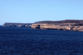
Pictured Rocks National Lakeshoreon the South Shore of Lake Superior
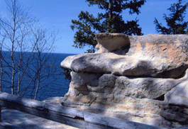
The sculptured rocks create images in your mind of fortresses and castles. Miners Castle, Battleship Row, Indian Head, Lover's Leap, the Color Caves, Rainbow Cave, and Chapel Rock are on ly a few of the breathtaking sights which can be seen. There are scenic overlooks, hiking trails, beaches, waterfalls, and campgrounds, but the Pictured Rocks are best seen by boat.
Back-Country Camping: There are 13 hike-in campgrounds and 7 group sites spaced every 2 to 5 miles along the Lakeshore Trail. Mosquito River and Chapel Beach have toilets. No potable water. Fires allowed in metal fire rings, no ground fires permitted. Camping in designated sites only. Permits required and are available at the Visitor Center at the blinking light in Munising or the Grand Sable Visitor Center just west of Grand Marais on H-58. Campgrounds in the Pictured Rocks National Lakeshore. There are also other rustic campgrounds in the Hiawatha National Forest or private campgrounds in the area. Hiking and Walking: The Pictured Rocks National Lakeshore has wonderful hiking trails. You can chose short trails or long for an easy walk or an energetic hike. Pick up your trail map at the Visitor Center at the blinking light and take water and a snack with you. Be prepared for sudden changes in the weather and enjoy this beautiful lakeshore. Pets are welcome along roads, some trails and beaches, drive-in campgrounds, and designated developed areas such as Miners Castle. Please keep them on a 6' leash and under your control at all times. Watch for signs as some trails are closed to pets because of sensitive vegitation or nesting birds. Pets are not permitted in the Lakeshore backcountry. Please watch for signs. For more information on Pictured Rocks National Lakeshore, call (906) 387-3700, write to Pictured Rocks, National Park Service, P.O. Box 40,Munising, Ml 49862 or visit their website at www.nps.gov/piro/index.htm
Directions The Pictured Rocks can be
reached at the western end by following Highway 28 or 94 to
Munising.
Adventure Vacation Packages All inclusive kayaking packages for fun in the Munising area. Guided paddling tour at the Pictured Rocks, stay at Paddlers Village, eat at t he Duck Pond Eatery and Beer Garden, take a dinner cruise, plus much more. Several packages available. Phone: 906-387-1695. Pictured Rocks Boat Cruises (906) 387-2379 from Munising offers a lakeside view of the cliffs and the Grand Island Shipwreck Tours (906) 387-4477, also available at Munising, takes visitors to three shipwrecks on the bottom of the lake as seen through a glass viewing area. Au Sable Lighthouse may be reached by following a 1.5 mile trail from Hurricane River Campground at Munising. Visit the historic Munising Coast Guard Station near the end of Sand Point Road and see the 36' motor lifeboat, "Grand Marais" in the old boathouse. Pictured Rocks Guided Sea Kayak Tours, Munising, Michigan. Enjoy the stunning beauty of the Pictured Rocks National Lakeshore from the water. We offer a variety of guided sea kayak tours for all ages and experience levels. All kayaking gear included. Uncle Ducky Paddling Michigan Shop, 1331 West M-28, Munising MI 49855. Phone: 906-387-1695
Visit Grand Marais, the Eastern Gateway to the Pictured Rocks. Visit Munising, the Western Gateway to the Pictured Rocks
Map of Munising end of the Pictured Rocks Map of Grand Marais end of the Pictured Rocks
Back
to Recreation Page Photos by Mary Deloria &
Vivian |