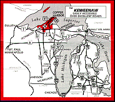
Maps showing the location of the Keweenaw
Peninsula
in the Upper Peninsula of Michigan

The name Keweenaw is from the Ojibiwas (Chippewas) meaning
"Portage". The ancient Portage River and Portage Lake provided a
natural water pathway across most of the Keweenaw Peninsula. The
short portage at the north end was opened into a canal in the late
1800's. Ships could now travel through the Keweenaw Waterway instead
of around the Peninsula and larger vessels could travel to Houghton
and Hancock. The Keweenaw Waterway also provided a Harbor of Refuge
to protect these vessels from Lake Superior's violent storms.
Completion of the Keweenaw Waterway made the Keweenaw Peninsula an
island rather than a peninsula.
In the mid-1800's the world's purest "native" copper was
discovered in the Keweenaw. Mining of this rare native copper led to
extensive development of the Keweenaw Peninsula. Many relics and
ruins remain.
The Keweenaw
Peninsula
Rock
Collecting in the Western Upper Peninsula
Snowmobiling in the
Keweenaw Peninsula
Snowmobiling
in the Upper Peninsula
Site Search
Engine
Back to Upper Peninsula Towns
and Cities
Back to the Upper Peninsula
Traveler
Back to Exploring the North Home
Page
Copyright 1998 by Vivian Wood, webmaster. All Rights
Reserved. Except as permitted under the Copyright Act of 1976, as
amended, this web site may not be reproduced in whole or in part in
any manner. Unless authorized by the webmaster, reproduction of any
picture, web page or pages on this website,
www.exploringthenorth.com, for placement on the internet is a
copyright infringement. All right, title and interest in and to the
material on these web pages, the web site, in whole or in part, and
in and to this url and the urls contained within, is the property of
the webmaster. All website design, text, graphics, selection and
arrangement thereof are the copyrighted works of Vivian Wood. Web
site created on an Apple G-4 |